

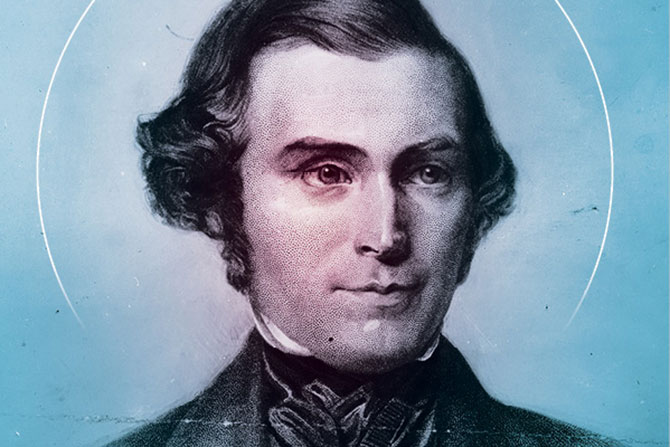
Feature Photo courtesy of The Church of Jesus Christ of Latter Day Saints, Image PH 328.
Spencer McCutcheon is a land surveyor with Apex Engineering. He’s been surveying for about seven years and has been licensed for three years. Spencer also loves history; this drove him to learn more about his family and, through his research, to discover that, among other things, he is the fourth great-nephew of Orson Pratt, who was also a surveyor.
During the Fall 2019 National Historical Society Convention, Spencer gave a presentation on the history of Orson Pratt’s surveying and the influence he had on establishing Utah and the Western U.S. The following is, in part, the presentation that was given.
Orson Pratt was born on September 19, 1811, in Harford, New York. Orson always loved school — he loved to learn, and his education was of the utmost importance to him. But he had to help his family and was required to work as a farmhand, and that took up a lot of his time. Orson’s goals of education were delayed, and in his own words, he said, “I was obligated to perform farm boy duties for various neighboring farms. Starting in spring and extended to the fall, which limited the time that I was able to dedicate to studies.” Orson continued with his education and farm work through his adolescence. Eventually, he enrolled in a boarding school in 1829 at the age of 18. Orson mentioned how much education meant to him and said, “I have made myself thoroughly acquainted with geography, grammar, arithmetic, bookkeeping and surveying.”
Orson took his knowledge of mathematics, geography, and surveying to the next level when he became a Professor at the University of the City of Nauvoo, where he was tasked to help educate the members of his faith.
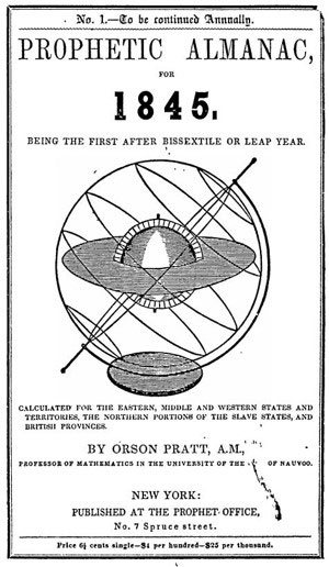
During his time as a Professor, Orson applied his knowledge and skills to help others by publishing his first almanac. In August 1844, Orson published the Prophetic Almanac for the year 1845. He then published his second almanac in August 1845. These almanacs had a lot of material on eclipses and when and where they could be observed; the expected time of sunrise, sunset and appearance of the moon; and spiritual thoughts and impressions he had.
During this time, tensions towards the LDS Saints began to increase, forcing them to look for a new land in the west. On Feb. 14, 1846, the Saints started leaving Nauvoo. Orson wrote in his journal about the weather during this time of persecution, saying, “Last night it commenced snowing. The falling of the snow and a cold northwest wind have made the weather very disagreeable.” Orson also wrote about the cold weather, saying, “The temperature at six am was five degrees above zero. The Mississippi froze over, and the ice soon became sufficiently firm for the crossing of teams.”
Orson also told of some hardships as they were on their trek west. One entry talks about how the buffalo affected the cattle and the company. He wrote, “During the whole day innumerable herds of buffalo were in sight on both sides of the river. Many hundreds feeding within a quarter mile of our road did not seem to be alarmed at our approach. During the time of our halts, we had to watch our cattle to keep them from mingling with the buffalo. I think I may safely say that I have seen 10,000 buffalo during the day. …”
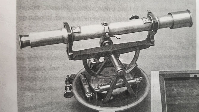
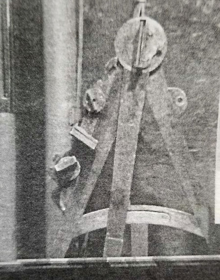
Even with all the persecution and the unknown future for the Saints, Orson still had a great attitude and continued his passion for surveying and astronomy. Orson was included in one of the first groups to travel west. He was given charge of surveying instruments such as the quadrant, artificial horizon of quicksilver, a sextant and telescopes. During the journey, Orson was to make observations and record information about the trip for future travelers and saints that followed the same trail west. These observations and notes were a crucial part of the success of the other companies as they headed West.
Field Notes
At the beginning of the saint’s journey west, Orson did not possess the most current and precise equipment at the time, making his observations even less precise than what was possible. He still did as instructed and made observations along the way. In early 1846, Orson wrote, “During our stay at Sugar Creek, I obtained, by means of a quadrant and an artificial horizon of quicksilver, a meridian observation of the Sun from which I deduced the Latitude of the camp and found the same 40°32’.”
Orson, on this same occasion, wrote of how the inaccuracies of this quadrant affected his measurement, “By a number of observations with the quadrant, I had previously ascertained the latitude and longitude of the Temple at Nauvoo. The latitude being 40°35’48”; the Longitude 91°10’45.” A quadrant, however is a very imperfect instrument for determining the longitude as an error of one minute (1’) in the instrument itself, or in the observation would produce in the calculated longitude an error of (30’) thirty miles. It is a misfortune that we have no sextant in the camp, neither a telescope of sufficient power to observe the immersions and emersions of Jupiter’s satellites.”
Sometime in 1846, Brigham Young acquired a sextant and a telescope and gave them to Orson Pratt. These new instruments helped Orson make significantly more accurate observations than he had been making with his outdated quadrant.
Orson continued to make observations all along the way with his quadrant, sextant, and artificial horizon on the sun, moon and stars to determine his latitude. He took the latitude of his camp every day that the weather permitted. Orson also recorded eight longitudinal observations at significant points along the way: Loop River, Platte River, Fort Laramie, Fort Bridger, South Pass and Temple Square.
In Orson’s field notes, he not only took observations to locate his latitude and longitude, but he also recorded the temperature of each morning, afternoon, and night using his thermometer. He took observations of the altitude of some of his encampments along the way to Utah, using his barometer, and he calculated elevations of peaks using his sextant and trigonometric measurements.
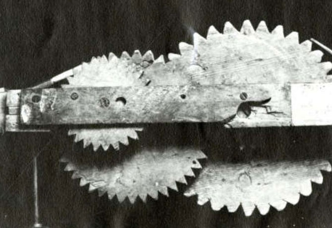
President Brigham Young called on Orson Pratt, William Clayton and several others to determine a way to attach some machinery to one of the wagons to keep track of the distance the company traveled in one day. The odometer had already been invented, so the challenge was coming up with something using their limited resources that could be tailored to traveling by wagon/handcart. Orson writes: “This afternoon, I proposed the (Bellwins) method. Let a wagon wheel be of such a circumference that 360 rotations shall make one mile. …”
The Saints then used this odometer to keep track of their mileage as they traveled to the Salt Lake Valley. On June 26, 1847, they halted at the last of the main branch of the sweet water. The measurement of the odometer read 275.5 miles since they started recording their miles. On July 21, 1847, Orson Pratt and Brother Erastus Snow entered the Salt Lake Valley. The rest of the company entered the valley four days later.
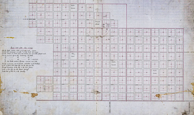
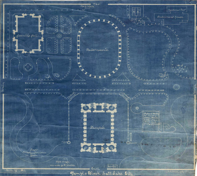
Temple Block
One of the first things that was established was the layout of the city. Orson Pratt was called on to carry out this duty. On July 31, 1847, he began the city layout. With the help of Henry G. Sherwood, the layout of the temple site began. They marked the Southeast corner of the temple site and started naming the city streets from this point. The layout of the Great Salt Lake City was done according to a vision that Joseph Smith had on June 25, 1833, titled the Plat of the City of Zion. The Plat shows the dimensions of the streets and blocks and describes how the blocks should be laid out.
After the establishment of Temple Square, there is no evidence that Orson Pratt participated in any more surveying within the city or surrounding areas — this may be due to his involvement with the church as an apostle. Henry G. Sherwood, Orson Pratt’s apprentice, became the Deseret Survey General and performed most of the surveys following the layout of Temple Square. Even though he may have stopped practicing surveying as a profession, Orson kept his enthusiasm towards the profession and his love for astronomy.

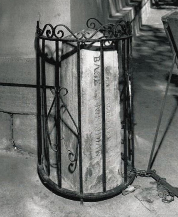
Base and Meridian
The initial point for the Public Land Survey System (PLSS) was chosen to be the southeast corner of Temple Square. This point was not intended by Orson to be the initial point of the PLSS; rather, he intended it to be the starting point of the lots in Great Salt Lake City. The United States government appointed David H. Burr to be Utah Territories’ first General Surveyor. Burr arrived in Salt Lake on July 27, 1855, and upon his arrival, he was to establish the initial point for the PLSS. Instead of setting his own monument, Burr took advantage of an established corner that the public was using. In September of 1855, Burr paid a well-known stonecutter by the name of Benjamin T. Mitchell to make a sandstone monument that he placed to mark this initial point. Burr then began contracting surveyors to begin the PLSS system in the Utah Territory.
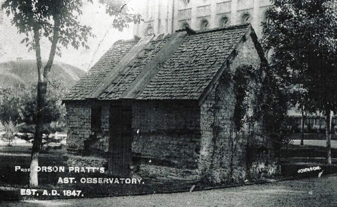
Pratt’s Observatory
In 1869, George W. Dean and F. H. Agnes were sent to Salt Lake City to get a precise latitude and longitude of the city to help establish the exact time for many of the main cities in the west. Dean asked Brigham Young if he would help them establish an observatory so that they could accomplish their work. Brigham Young agreed to help Dean construct the observatory and even provided the funds for the construction. The building was named after Orson — Pratt’s Observatory. Today, Pratt’s Observatory has been moved; the building is located at This is the Place Museum in Salt Lake City.
Conclusion
Utah’s history of surveying is very complex and loaded with information, as well as rich with documented accounts from many individuals. Orson Pratt’s contribution is only a fraction of this history, but it is an essential part. His notes and journal entries are full of observations, calculations, and stories about his surveying experiences. He accomplished these great achievements using primitive equipment.
Orson has contributed greatly to our heritage and is one of the great surveyors that helped shape our state and our country. A Base and Meridian monument has been erected to honor all of the work that has been done. It can be found on the southeast corner of Temple Square.